Wednesday 17 September 2014

Update: Showers Possible Across Northern California Wed/Thu

Update: Showers Possible Across Northern California Wed/Thu

Wednesday Evening Update

998mb surface low is sitting off the northern California coast at the moment, which will move inland through the day Thursday and quite quickly weaken. Upper low/trough featuring this surface low also looses its punch as it stretches apart. Models continue to show uncertainty regarding the leftover closed upper-low, with some model runs taking it offshore and some cutting it off over central and southern California. Some of these solutions would support an offshore wind event Friday, perhaps into Saturday, which wouldn’t be the best for firefighters working fires across interior northern California, with the King fire at top-priority.
316
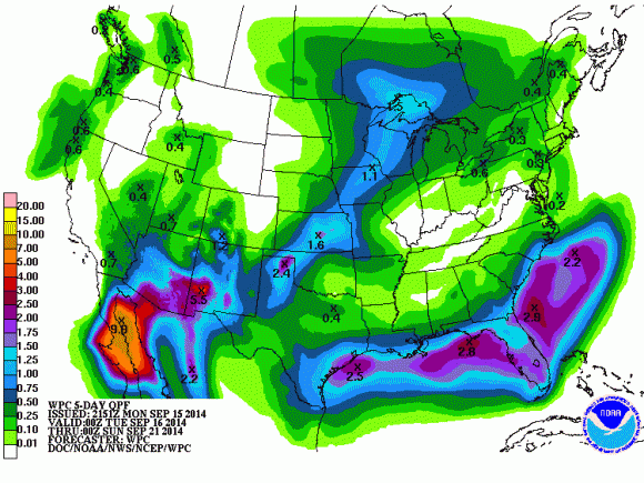
Now precipitation wise, models have grown dryer over the last 24 hours. It appears the best chance of precipitation will be along the coast, coastal mountains, northern Sacramento valley, northern mountains, and orographically enhanced slopes of Plumas and Lassen counties. However, some very light QPF is still generally indicates as far south as Sacramento, with the best chance overnight Wednesday into Thursday morning.
4km NAM's forecast QPF through Thursday afternoon. Just a model prediction, and certainly has potential to be way off.
4km NAM’s forecast QPF through Thursday afternoon. Just a model prediction, and certainly has potential to be way off.
Some instability is still forecast across northern California, including the Sacramento valley Wednesday morning into the afternoon. Best instability for the valley appears to be in the morning before shifting into the foothills/sierra. Dryer air unfortunately slides into northern California through the day Thursday, so while instability increases, moisture lessens. Nonetheless, some convective showers appear possible Thursday morning across a good chunk of northern California, transitioning into the higher terrain mainly by afternoon.
0z 4km NAM's forecast SBCAPE valid at 2pm.
0z 4km NAM’s forecast SBCAPE valid at 2pm.
It’s been a long, dry, and quite boring last several weeks across northern California weather wise. The dry conditions have allowed for explosive growth of wildfires across northern California, with the latest two fires exploding over the last few days including the King Fire in El Dorado county and the Boles Fire up in Siskiyou county, which burnt through subdivision in Weed, damaging and destroying around 100 structures, many of them homes. The fire that has burnt the most acreage is the King Fire, and has burnt nearly 12,000 acres as of this morning, likely pushing 13,000 – 14,000 acres this afternoon.
MODIS aqua imagery from this afternoon.
Weather-wise, about 400 miles off the Oregon/northern California coast lies a large upper-level low, with a surface low about 400 miles of the San Francisco coast. With this somewhat vertically-tilted low, blobs of cloud cover, and precipitation can be noted offshore via satellite imagery, with some convection also present given there’s some cooler air aloft with the system supporting some instability.
Visible satellite imagery from 5:25pm Tuesday.
As the system as a whole slides eastward through the day Wednesday, a front is expected to slide through northern California west to east between late Wednesday afternoon and Wednesday evening, depending what model’s timing is closer to being correct. Lapse rates steepen up a fair amount as the front slides through, with 6.5 – 7.5c 700 – 500mb LRs modeled by the 4km NAM early Wednesday evening… however the NAM in general is very dry with this system compared to global models such as the ECMWF, GEM, and GFS, and given the majority of other models are wetter, they’re the ones to lean toward for now. Believe the slight increase in instability and increasing moisture from the offshore low as it sends in an influx of .8 – 1.1″ precipitable water values combined with a band of increased vertical accent overnight Wednesday into Thursday should be enough to generate at least some showers across a good chunk of northern California. Low slowly pushes inland during the day Thursday, continuing shower chances across the region.
September 16th
GFS indicates a fair amount of CAPE/negative lifted-indexes as the core of the upper-low slips overhead from late Thursday morning into the afternoon. NAM has similar instability, but doesn’t indicate much development. The SREF also has a fair amount of CAPE, but does have a little QPF Thursday morning/early afternoon. ECMWF and GEM also indicate some QPF during the day Thursday, leading me to believe the NAM is still off here. Given forecast instability, I’d say there’s a decent chance of some thunderstorms during the day Thursday, with the best chances over the coastal mountains and west slope of the sierra and sierra itself. There’s just as much instability being modeled in the portions of the valley as in in the higher elevations, so some valley/foothill storms also seem possible, given most global models also have QPF in parts of the Sacramento valley and adjacent foothills. Interestingly enough there is some weak directional shear forecast, and LCLs aren’t too high during the late morning/early afternoon Thursday. I’ll have another update regarding this system Wednesday evening and see if any high resolution models show any potential with this instability and shear.
18z 12km NAM's forecast MLCAPE for around 5pm Thursday.
18z 12km NAM’s forecast MLCAPE for around 5pm Thursday.
In total, the GFS/GEM/ECMWF would drop around a tenth of an inch of precipitation for a good chunk of northern California… with upwards of a quarter to half of an inch in luck locales in the coastal mountains and north coast. Will update these forecast amounts if things change by later Wednesday model wise.

Tuesday 16 September 2014

Major Hurricane Odile slams Baja Peninsula in Mexico

Major Hurricane Odile slams Baja Peninsula in Mexico

Infrared imagery showing a Category 3 storm making landfall. Image Credit: NOAA
Infrared imagery showing a Category 3 storm making landfall. Image via NOAA
The active Eastern Pacific hurricane season continues to churn up powerful storms. On September 15, 2014 at 12:45 a.m. EDT (445 UTC), major Hurricane Odile slammed into Mexico’s Baja Peninsula. It made landfall in Cabo San Lucas, a popular tourist destination, with a population of roughly 70,000 people. The storm made landfall as a Category 3 storm with sustained winds of 125 miles per hour (mph) or 110 knots. Odile was the first known storm to hit Cabo San Lucas as such a strong intensity. Odile ties with Hurricane Olivia (1967) as the strongest hurricane to make landfall in the satellite era in the state of Baja California Sur. Heavy rain, flooding, and damaging winds were the main threat as it pushed ashore. Fortunately, the storm was undergoing an eyewall replacement cycle, which typically means a gradual weakening until a new eye forms. However, despite the cycle occurring, the National Hurricane Center did not see much in weakening as it crashed ashore. There is no doubt we’ll see some extensive damage out of that area. Flooding will be the biggest concern as it continues to push to the north.
Hurricane Odile on September 14, 2014. Image Credit:  Jeff Schmaltz, LANCE/EOSDIS Rapid Response
Hurricane Odile on September 14, 2014. Image Credit via Jeff Schmaltz, LANCE/EOSDIS Rapid Response
Hurricane Odile produced damaging winds that toppled over trees and power lines. Windows from cars and buildings shattered from the howling winds. Los Cabos airport received extensive damage, and it is unknown for how long it will be closed. Cabo San Lucas is a popular location for travelers, and several hotels received significant damage. Based off images online, it looks like a good bit of the damage was actually from damaging winds that gusted over 100 mph. As of now, there have been no reports of deaths related to this storm.
Damage in parts of Los Cabos. Image Credit: Twitter via @MexicanadeModa
Damage in parts of Los Cabos. Image via Twitter via @MexicanadeModa
Hurricane Olivia is one of the few storms that matched the strength of Odile. Image Credit: CNN Weather
Hurricane Olivia is one of the few storms that matched the strength of Odile. Image via CNN Weather
Extensive damage in the Los Cabos Airport. Image Credit: Twitter via @MexicanadeModa
Extensive damage in the Cabo San Lucas Airport. Image via Twitter via @MexicanadeModa
iCyclone, a hurricane chasing group led by Josh Morgerman, was in Cabo San Lucas as the storm made landfall. They were able to document the series of events as the conditions deteriorated. Through Twitter and Facebook, Morgerman was able to describe his experience as the storm battered them, when it began to calm as the eye was passing over them, and the violent conditions that occurred as the second half of the storm pushed through.
iCyclone on twitter was tweeting their experiences as Hurricane Odile slammed ashore. Image Credit: Twitter
iCyclone on twitter was tweeting their experiences as Hurricane Odile slammed ashore. Image via Twitter
On Facebook, Josh Morgerman went into great detail on his experiences as the storm battered Cabo San Lucas:
Midnight. CODE RED. At 11:46 pm, the backside of the eyewall hit — no buildup — just all of a sudden the howling and banging started up again. The hotel manager joked that it sounded like gunshots. Then at maybe midnight… BOOM!!!!! The entire glass wall of the lobby EXPLODED– with glass, pieces of building, everything flying to the other end of the lobby. Like an explosion in an action movie. A hotel worker and I ducked under the reception counter — I physically grabbed his head and pushed it under the counter. Glass was everywhere — my leg gashed — blood. We crawled into the office — me, the worker, and the manager — but the ceiling started to lift up. After five minutes of debate — breathing hard like three trapped animals — we made a run for it — went running like HELL across the lobby — which is now basically just OUTSIDE — and made it to the stairwell and an interior hallway. Two nice women dressed my wound. I don’t know where my cameradude, Steven, is. I need to find him. People are scared.
Damage to the hotel in Cabo San Lucas. Image Credit: iCyclone via Facebook
Damage to the hotel in Cabo San Lucas. Image via iCyclone via Facebook
1 am. I found Steve — we were tearfully reunited. I say tearfully because I was so happy to find him alive and OK in the chaos I got emotional. After roaming the flooded, dark hallways alone, I found him sheltered in a bathroom next to the lobby with two other guests. The lobby itself is a heap of wreckage. Steve was in the cloud of flying glass as that wall exploded. Like us, he had to run like hell — and like me, he was bloodied. Steve saw me and my partners scampering like rats across the lobby earlier– when we made our escape– but I didn’t hear his calling over the roar of the wind. What you see here is my leg — dressed in a towel — Steve’s wound dressed in duct tape, and a shoe he fashioned out of duct tape (because he lost his). We’re in an interior hall now. We’re OK. I think the wind is quieting down. I think. Parts of the hotel are smashed beyond recognition.
Possible rainfall totals over the next five days. Image Credit: Weather Prediction Center
Possible rainfall totals over the next five days. Image via Weather Prediction Center
Hurricane Odile is expected to weaken as it pushes further inland, cutting itself off from open waters and a favorable environment for sustaining itself. The storm is expected to affect parts of the Southwest United States where it could produce heavy rain and flooding. The Weather Prediction Center is forecasting rainfall totals of over three inches possible in parts of Arizona and New Mexico. The remnants of Odile will actually be absorbed into a large trough that will dig into the Central and Eastern United States by the end of the week.
Image Credit: Twitter via ?@MexicanadeModa
Bottom line: Major Hurricane Odile made landfall late Sunday evening (PDT) on September 14, 2014 as a Category 3 storm and sent damaging winds and heavy rain into parts of Cabo San Lucas. Windows were damaged, power was out to thousands of people, and the Los Cabos airport saw extensive damage. Clean water is becoming scarce, and communication is poor. We probably don’t understand how bad it is at this moment due to poor communication out of the region. Typically it takes time to realize the true extent of damage and chaos after a devastating storm as communication is lacking. It is one of the most powerful storms to ever hit the region. Prayers go out to the people affected in that region.

Portland Radar. NEXRAD Radar.

Weather On The One, Current National Temperatures

Weather.com Radar

Northern Weather