Thursday 20 November 2014
Thursday 13 November 2014
Listen to This: Comet's Eerie 'Song' Captured by Rosetta Spacecraft
Listen to This: Comet's Eerie 'Song' Captured by Rosetta Spacecraft
by Miriam Kramer, Space.com Staff Writer | November 11, 2014 06:56pm ET

Scientists have picked up on the "sound" of Comet 67P/Churyumov-Gerasimenko speeding through space.
Credit: ESA/Rosetta/NavCam
View full size image
"This is exciting because it is completely new to us," Karl-Heinz Glaßmeier, head of Space Physics and Space Sensorics at the Technische Universität Braunschweig, Germany, said in a statement. "We did not expect this and we are still working to understand the physics of what is happening."
Rosetta's magnetometer experiment first recorded the song when it was flying within about 62 miles (100 kilometers) of the comet in August. The magnetometer is part of a five-instrument suite, called Rosetta's Plasma Consortium (RPC). The instruments are designed to monitor
 how the comet interacts with the solar wind and plasma emitted by the sun. The RPC also looks at the structure of the comet's atmosphere, known as a "coma." (Glaßmeier is also the principal investigator for the RPC.)
Tomorrow (Nov. 12), Rosetta is expected to release its Philae lander down to the surface of Comet 67P/C-G. If it works, the landing will mark the first time humans have soft-landed a probe on the face of a comet. You can keep up with the landing in a live Philae webcast on Space.com
Rosetta and Philae will be responsible for gathering data
about the comet to help scientists learn more about the icy wanderers, remnants from when the solar system formed billions of years ago. Rosetta should keep studying the comet from orbit until December 2015, after its close approach with the sun in August. If Philae's landing is successful, it should be able to study the comet from its landing site until March 2015.Saturday 8 November 2014
A Look at This Evening's Model Runs - Major Snow For Upper Midwest Possible
A Look at This Evening's Model Runs - Major Snow For Upper Midwest Possible
November 8, 2014
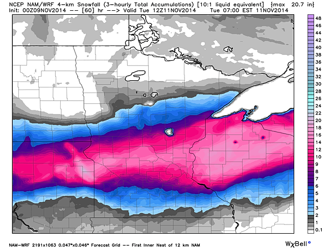
I want to start off by showing you snowfall accumulations that the hires NAM and GFS are showing. Tonight's run of the hires 4km NAM has 6+" of snow falling from the Dakotas toWisconsin where Winter Storm Watches and Winter Storm Warnings are in effect.
The GFS isn't as extreme with totals other than the fact that it has central/northern Wisconsin getting most of the snow which is similar to the hires NAM.
Snow will likely be falling Monday morning across the upper Midwest region.
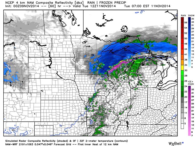
By Tuesday morning the bulk of the snow will likely be over the Wisconsin region where we could be seeing some isolated showers across the St. Louis area as the cold front moves through the area.
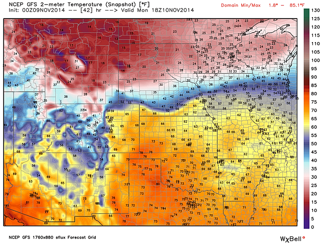
There will be quite the temperature contrast across the Midwest region Monday. St. Louis is expected to get well into the 60s Monday so make sure you can get outside for a while as temperatures will be turning cold mid to late week!
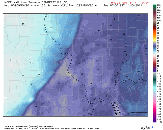
A cold front will be pushing through the area Tuesday morning bringing much colder air behind it! Note how the hires 4km NAM has St. Louis in the low 50s Tuesday morning, but places like Kirksville could be in the low 30s at the same time! Either way, our best chance of light rain will be as the cold front moves through.
As far as next weekend goes, the evening run of the GFS is still showing the potential for a snow maker for the St. Louis area, but again it's too early to get into details about that potential system.
Friday 7 November 2014
Bering Sea Superstorm: Hurricane Force Wind Warnings Issued Around Alaska's Aleutian Islands
Bering Sea Superstorm: Hurricane Force Wind Warnings Issued Around Alaska's Aleutian Islands

A Bering Sea Superstorm is now developing, partially from the former , and will whip up hurricane-force winds in parts of Alaska's Aleutian Islands as well as giant waves in the Bering Sea.
As of Friday morning, U.S. time, the ex-Nuri was deepening quickly south of Russia's Kamchatka Peninsula. Sustained winds first topped 40 mph around 5 a.m. AKST in , located in the far western Aleutians.
The ex-Nuri has joined up with the polar jet stream and a very strong disturbance in the mid-latitude belt of westerly winds, leading to explosive development of low pressure.
Forecasts from both the European (ECMWF) and American (GFS) computer models have consistently predicted this extremely powerful non-tropical storm to bottom out at peak intensity below 930 millibars over the western Bering Sea, near the western Aleutian Islands of Alaska Friday night into Saturday.

In fact, both models have repeatedly suggested the pressure of that post-tropical storm could go as low as 920 to 925 millibars -- almost as low as its estimated pressure was as a super typhoon. If that happens, it would be the strongest low-pressure system ever observed in or near Alaska since October 25, 1977, when a 925 millibar pressure reading was recorded on a ship docked at Dutch Harbor, Alaska. This system may also potentially be one of the lowest sea-level barometric pressures ever observed on Earth outside of tropical cyclones and tornadoes.
(MORE: )
For reference, the lowest central pressure of Hurricane Andrew (1992) was 922 millibars. Despite the potential of a similar pressure at its peak, wind speeds in extratropical cyclones such as the upcoming storm are much lower than hurricanes, because the pressure gradient is spread out over a much larger area than in a hurricane.
Potential Impacts
The map below shows the European model wind speed forecast for Saturday morning, with the darkest red colors showing the strongest wind speeds in the western Aleutians and east of Russia's Kamchatka Peninsula.

A large swath of very strong sustained winds, at times hurricane-force, will howl over the western Aleutian Islands of Alaska and adjacent Bering Sea.
The National Weather Service in Anchorage has issued a hurricane force wind warning for the waters surrounding the far western Aleutians as well as parts of the southwestern Bering Sea. Sustained winds could reach 80 mph in those areas.
Meanwhile, a for the far western Aleutians themselves through Saturday morning. In addition to the strong sustained winds pictured on the map above, there could be localized gusts of 90 mph or higher, especially where rugged terrain enhances the winds. The strongest winds will be southerly to southwesterly in origin.
Fortunately, the storm is forecast to lose some of that ferocity later in the weekend, but may remain somewhat stalled over the Bering Sea into Sunday or Monday.
These strong winds, coupled with the potential long duration of this storm, will whip up giant waves over parts of the Bering Sea and north Pacific Ocean.

Wave heights will likely top 45 feet near the western Aleutian Islands Friday night into Saturday, making for very dangerous conditions for all marine vessels not protected.
Swells around 22 feet may reach the eastern Aleutians and Pribilof Islands, including , Saturday into Sunday. St. Paul (population: 453) is notorious for intense storms, with a harbor that is susceptible to southwest winds, according to the .
A Jayhawk helicopter crew was sent by the U.S. Coast Guard to Cold Bay, Alaska, and the Cutter Munro was put on alert to help boaters stranded in the storm, if needed, .
As these large swells finally reach the coast of western Alaska, some minor coastal flooding and erosion is possible Sunday into Monday.
")
")
Thursday 6 November 2014
Extreme weather in North America likely, thanks to Typhoon Nuri
Extreme weather in North America likely, thanks to Typhoon Nuri
 |
|
According to scientists, October’s Super Typhoon Vongfong was the planet’s strongest storm for 2014.
Nearly a year ago (November 7, 2013), Super Typhoon Haiyan formed and devastated parts of the Philippines with sustained winds of 190 miles per hour, making it the strongest land-falling tropical cyclone ever recorded. It is still considered one of the strongest storms in the past thirty years.
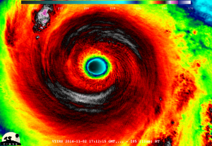
Unfortunately, another super typhoon formed in the Western Pacific this past weekend that has tied with Super Typhoon Vongfong as the strongest storm of 2014. Super Typhoon Nuri peaked on Sunday (November 2, 2014) with sustained winds near 180 miles per hour (mph) or 290 kilometers per hour (kmh). Nuri has weakened since the weekend, and it is expected to stay east of Japan as it pushes off to the northeast into the northern Pacific Ocean. A trough will pick up Nuri, and the models are expecting the storm to bomb out near the Bering Strait. The storm has the potential to become the strongest storm in that region in recorded history. Nuri’s size and magnitude will likely influence the jet stream’s orientation over the Northern Hemisphere, thus resulting in an extreme weather pattern across North America.
Yes, weather in the Western Pacific can indirectly affect the overall weather pattern across the Northern Hemisphere.

Suomi NPP VIIRS Infrared image of the eye of Super Typhoon Nuri in the West Pacific Ocean on November 2, 2014.
On November 2, forecasters thought Super Typhoon Nuri might strengthen further into a 195 mph storm with gusts near 235 mph. Fortunately, it peaked at 180 and started to gradually weaken on Monday. Nuri becomes the sixth Super Typhoon of the Western Pacific season, largely due to the unusually warm waters and favorable atmospheric conditions across the Western Pacific basin.
The storm will gradually weaken over the next couple of days into a tropical storm. It will stay east of Japan and move out into the Northern Pacific Ocean.
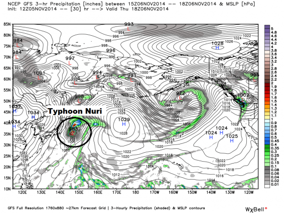
GFS model showing Typhoon Nuri on November 6, 2014. Image Credit: Weatherbell
As it gains latitude, the storm will transition from a warm-core low to a cold-core low, also known as an extratropical cyclone.The Northern Pacific jet stream will enhance the storm’s intensity. It will begin to “bomb out”, meaning the barometric pressure will drop drastically.Bombogenesis is a meteorological term used to define mid-latitude cyclones that drops at least 24 millibars within 24 hours.
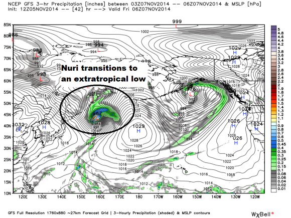
Typhoon Nuri becomes extratropical as it gains energy from the Northern Pacific jet stream. Image Credit: GFS via Weatherbell
It’ll become a super strong storm with a pressure around 915 to 922 millibars. Imagine a “Superstorm Sandy” over the North Pacific instead of the east coast of the United States. The storm will affect the Bering Strait, and extreme winds and surf is expected.

A mega storm forms near the Bering Strait Friday evening into Saturday morning via GFS model. Image Credit: Weatherbell
According to Andrew Freedman of Mashable,
To put that into perspective, consider if the storm’s minimum central pressure bottoms out below 925 millibars — as is currently forecast by most computer models — it would set a record for the lowest pressure recorded in the Bering Sea. The current record holder is 925 millibars, set in October 1977 in Dutch Harbor, Alaska
The storm will affect parts of the Alaska coast by Friday into Saturday. Some areas will likely experience hurricane force winds, high seas of 30 feet or greater, and minor coastal flooding/erosion in parts of southwest Alaska coastal areas. Some of our weather models are even projecting waves as high as 50 feet!
https://www.youtube.com/watch?v=qrqhscaqUIk
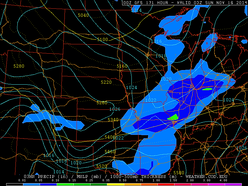
The storm will influence the jet stream and atmospheric patterns across the Northern Hemisphere. It will likely trigger a ridge of high pressure across the Eastern Pacific and into Western North America. Meanwhile, it’ll likely contribute to a large trough that will dig down into parts of Central/Eastern Canada and the United States. As the jet stream digs south, it will likely bring the year’s first round of arctic air into the regions. Some of the weather models are indicating the potential for single digits in the Northern Plains by late next week (November 13-15). It is still uncertain if it will produce a big storm for the eastern United States. However, both the GFS and ECMWF models indicate a significant surge of cold air into the area.
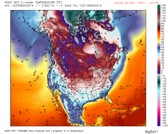
Big surge of cold air will hit Canada and the Central/Eastern U.S. by November 13-15, 2014. Image Credit: GFS via Weatherbell
The Climate Prediction Center is in agreement with a significantly colder weather pattern setting up for next week. They are forecasting temperatures well below average for Central and Eastern United States with above average temperatures likely along the west coast of Canada and the United States.
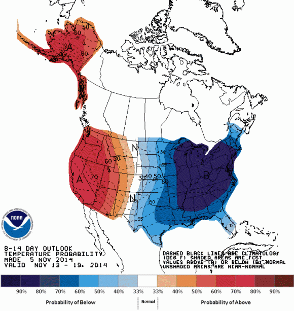
Temperatures will likely be well below average for the central and eastern parts of the United States by next week. Image Credit: Climate Prediction Center
Bottom line: Next time someone asks you how weather in the Western Pacific can affect the weather patterns across North America, you might direct them to this article. Nuri will likely cause hurricane-like conditions along the Bering Strait as it becomes extratropical (no longer a tropical cyclone). It will help amplify the jet stream and likely produce a surge of very cold air that will reach parts of central/eastern Canada and the United States by November 12-15, 2014. There remains uncertainty regarding how cold the pattern will be, but as soon as our models get within three to five days of the forecast, we will truly get a better idea of the overall setup and if a storm will develop.
Subscribe to:
Posts (Atom)
Portland Radar. NEXRAD Radar.
Weather On The One, Current National Temperatures
