..I’m a Owner & Operator specializing in Public safety involves the prevention of public protection system !... This SITE was created for the sole purpose of providing weather information before and during severe weather. Please don't like warnings. Share them only......Analyst Weather forecast, Chasing storms and tornadoes B.E.C.T is an California-based storm team whose main goal is to alert/update people on severe weather. Social Media is Public ..... We are here to Help Others ......
Pages
- Home
- Convex Tornado Forecasts / Weather Warnings by BlueWolf
- Rain Gauge == Santa Rosa Ca.
- Radar and Satellite
- Current Conditions
- imapweather
- Extreme Chaser Team
- Severe weather
- Storm Chasing
- Mesonet And Models
- Short Range Ensemble Forecast (SREF) Products
- Notes
- Wind
- What Happened on May 29, 2013 ?
- Winter 2013 - 2014 US Forecast
- WX Models & Other links
- Winter WX Maps
- U.S Weather Maps
- FutureCast Simulated Radar Loop
- EARTH - WIND - MAP
BlueWolf Extreme Chaser
Wednesday 31 August 2016
Sunday 14 August 2016
Wednesday 10 August 2016
Wednesday 3 August 2016
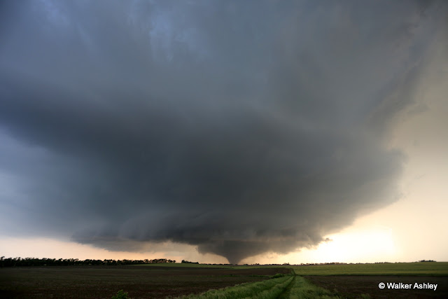
5/25/2016 - Chapman, KS EF4 Tornado
|
Posted: 02 Aug 2016 12:12 PM PDT
This was an unusual day in that a slight risk with a 2% tornado risk went on to produce a long-track violent tornado, of which I witnessed the latter half of its life-cycle. Spent most of the day thinking the area from McPherson to Wichita would be the hot spot, getting suckered south and east of El Dorado to a long-lasting LP with a base that could've fit within a high school gym. Meanwhile, a long-lived supercell -- and storm of the day -- had formed near Salina. Keeping a radar eye on that storm, while holding firm on this southern LP thinking it was going to eventually take-off, was a mistake. Finally, we blasted north toward the I-70 storm, taking in the Flint Hills about as quick as one can with a mediocre internal combustion engine. It was a long slog up, but we eventually caught eye of the tornado near Enterprise, KS. We positioned north of Detroit, KS and took in the classic tornadic supercell for a bit, before having to scurry east and south as the bear came munching. Stopped a few times -- once northwest of Chapman, another east of Chapman, and then south of Junction City -- to view the beast, which would alternate from rain-wrapped to visible. Watched the tornado dissipate south of Junction City from a perch on US-77.
Stitched panoramic north of Detroit, KS
Stitched pano with Chapman, KS in valley ahead of tornado.
|
Subscribe to:
Posts (Atom)
Portland Radar. NEXRAD Radar.
Weather On The One, Current National Temperatures


