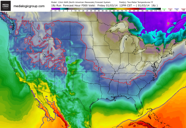
Polar Plunge. If it’s any consolation sub-freezing weather may push as far south as Orlando. Mickey and Goofy are not amused. Subzero temperatures will push across the Midwest and Great Lakes into the Ohio Valley and New England next week. The solid green line marks the 0F isotherm, the solid red line: 32F. It’s going to get so cold over the Upper Midwest we actually ran out of colors. First time for everything. Loop: NOAA’s NAM model and Ham Weather.
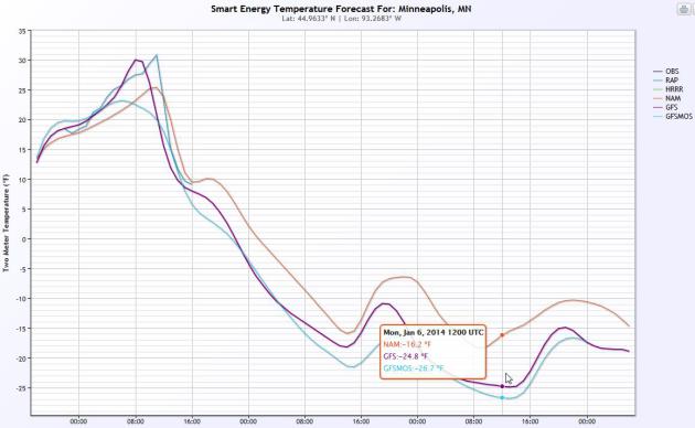
Dueling Models. By 6 AM Monday temperatures are forecast to close to record values, ranging from -16F (NAM) to -24 (GFS) to -26 (GFSMOS), the coldest in at least 10 years, possibly since 1996 for much of Minnesota. Source: Smart Energy.


Saturday, Jan 04, 2014
Everybody, Chill!
Yes, Mr. Freeze sums it up the best way. But it won’t just last tonight, but it will be around through Tuesday as some of the coldest air in decades comes down from Canada and the Arctic Circle. Image fromQuickmeme.com.
A surge of arctic air is going to move through across the country, from the Midwest, and fan out towards the East Coast, Southeast and Southern Plains over the course of the next few days. Daytime highs in many locations could break records for being the coldest temps ever felt in those areas.
Wind chill warnings cover 5 whole states (North & South Dakota, Minnesota, Iowa, Wisconsin) and fan out into at least 6 other states from the Midwest to the Ohio River Valley. The conditions will be very dangerous for anyone to be out more than a few minutes, as frostbite can kick in on anyone that isn’t wearing several layers. Wind chill values will be ranging between -25° to -60° across the gray shaded area above! Image fromecmwf.int.
This historic bout of arctic air is coming down from the North Pole as the polar vortex descends down into the lower 48. The polar vortex is the pattern of winds around the North Pole, where all the arctic air is locked up usually. A huge slab of the arctic air has been dislodged and the polar winds will drop down into the country, as far south at the Gulf of Mexico.
On Sunday, the morning lows will be sub-zero as far south as the Central Plains and as far east as Pennsylvania. Temperatures shall be around 30 to 40 degrees colder than the seasonable highs for that day in the Midwest. A storm system that will bring a wintry mix and heavy, wet snow to the Ohio River Valley Sat night to Sun, shall be pushing warm, moist air up ahead of it, so highs on Sunday along the East Coast shall be on the rise.
By Monday, the polar air shall dominate the Midwest, creating temperatures so cold, that it will be hazardous to your health to be outside more than a few minutes. High temps will be around early on in the day in the Northeast, and then the storm system will cross the area, and temperatures will drop through the day. The Florida Panhandle shall be around 25° colder than normal and it will feel, with some winds, into the 20s for highs! Temperatures in Caribou, ME will be warmer than in New Orleans on Monday.
As we progress into Tuesday, the cold air shall continue to hold on tight to the Midwest, with sub-zero highs coming around again for portions of the Dakotas, Minnesota and Wisconsin, although there will be some slight warm up (I use that term loosely) coming into the Midwest. However it will still feel bitterly cold from the Midwest, to the Southeast, as wind chill values will range in the negative teens to the teens. Even Miami will see cooler than average temperatures, although they will have much favorable weather than most of the lower 48.
Day time highs will rebound through the week ahead, and by Friday, we can thankfully see much of the country getting warmer than average temps coming around. Yes, 20s in the Midwest doesn’t seem warm, but when you have to face negative teens for highs, anything above zero will seem like a mild, Summer day.
Stay warm and stay safe. This arctic air is nothing to joke with and can be life-threatening if proper steps are not taken to safe guard from the cold.

No comments:
Post a Comment