Rainy Night Ahead, Showers Lingering into Thursday
JANUARY 29, 2014
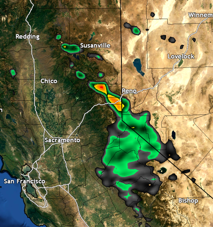
It’s been a cloudy, wet day across portions of northern California today outside of the delta area and the west side of the Sacramento valley where some rain shadowing has taken hold. Outside of those areas, the east side of the valley, portions of the coast, coastal mountains, west slope of the sierra (& sierra itself of course), and the foothills have nearly all seen measurable precipitation from around north of Jackson. Personally, here in Rocklin (Placer county), I’ve picked up .14″ thus far ahead of the main precipitation band.
Offshore as of 7:30pm, an upper low about 700 miles offshore from the coast of northern California is pulling up a long fetch of sub-tropically based moisture, with the tropical convective source blooming over Hawaii. This sub-tropical moisture plume-infused 100 – 130kt jet streak has been blasting northern California/Oregon today, and is what is assisting in the intensifying offshore precipitation band associated with the upper low and it’s cold front.

Given precipitable water values of 1.2 – 1.3″ and rather strong 700mb vertical velocities indicative of strong vertical motion (lift) along and ahead of the cold front along the frontal precipitation band, moderate to heavy precipitation seems in order once the system begins pushing ashore. Nose of the precipitation was just beginning to make it inland as of 7:35pm, and thus expecting precipitation to become widespread again after 8:30 – 9pm tonight (Thursday). Frontal precipitation will continue through around 2 – 3am in the Chico area, cutting off around 3 – 5am in the Sacramento area.

1z HRRR indicating moderate to perhaps heavy precipitation ahead of cold front late tonight into the early morning hours of Thursday.
Given 850mb temps ahead of the front remaining above 4c or so through 12 – 2am, snow levels will remain above 6000ft through at least 1 – 2am. After around 2am, I’m more confident that snow levels will dip down to around 4000ft by 4 – 5am. While the front will slide through the South Lake Tahoe area around 3 – 5am, moist upslope flow will continue through morning Thursday continuing precipitation development up the west slope of the sierra to the sierra crest.

Snow increasing in areal coverage (blue) through the overnight and morning hours of Thursday.
Total QPF amounts still look to be around .25 – .75″ in the valley, with 1 – 3.5″ in the mountains, with the heaviest amounts along southwest facing slopes. This translates to about 1 – 2ft of snow above 7000 – 7500ft, with 6 – 12″ above 5000ft, and a few inches down to 4000 – 4500ft.

Convection:
Models have pushed back the timing of the upper low itself to slide across northern California to the late afternoon during the evening hours, which won’t be very favorable for strong convection due to the best source of lift being that low, and with it offshore it wouldn't be close enough to northern California to produce the lift we need. Despite this, it appears this may be a good setup to see some pockets of clearing by mid to late morning Thursday behind the overnight front and the upper low. With -20 to -25c 500mb temperatures aloft within the trough diving overhead Thursday and surface temperatures warming upper 50s and locally low 60s in the valley with 30s and 40s in the mountains, low-level lapse rates should rise on up into the 6 – 8c range, with a plume of moderately steep mid-level lapse rates also sliding overhead Thursday afternoon as the trough’s base places itself over northern California.

Given the upper low is now forecast to remain offshore until late Thursday, shear will remain rather weak through the day Thursday. Despite that, surface based CAPE values are forecast in the 200 – 500 j/kg range in the foothills, and mountains north of Highway 50 Thursday afternoon. The RAP even indicates some MLCAPEs of 300 – 500j/kg from Placer to Butte county, which is pretty decent for northern California given we typically with with low instability setups in the winter months. While lift won’t be too significant, upslope flow and more upper level lift is forecast to be present Thursday afternoon within the base of the trough, mountain convective initiation seems most likely Thursday afternoon, with storm motions being for the most part from north to south.

0z 4km NAM’s forecast mixed-layer CAPE valid for mid-afternoon Thursday, indicating rather decent values in the west slope of the sierra and north-central mother-load foothills.
There is a slight chance the low could move a bit faster than forecast and support some convective development in the valley, but the “slight chance” is key. Certainly not a given in this case. The best chance in the foothills would be from Sonora south, given the jet will be further south associated with the front in southern California during the day Thursday.
0z 4km NAM’s forecast reflectivity valid for the later afternoon Thursday, indicating some convection over the northern sierra.
Thunderstorms in the mountains would be capable of hail, very heavy rain or snow depending on elevation/location, and gusty winds given undirectional shear profiles.
Things clear out through the day Friday, and should remain dry across most of northern California through at least the middle of next week, at least based on current models. One additional low within the trough is expected to slide down the coast Sunday into Monday, if current models are correct with the track, all precipitation may remain offshore with the system, despite perhaps some showers in the northern mountains.
As while this system will bring us some much-needed precipitation, this won’t be nearly enough to even nudge the current severe drought we’re stuck in, it would take another 15 or so of these systems to effectively put a hamper on our current drought, and it doesn’t look like we’ll have a train of storms of that magnitude in the near future.
Whenever a new system arises, I’ll post an update. Some indications that a trough could get in here late next week, but there’s considerable disagreement at the moment.
Post your rainfall totals in the comments or on the Facebook page if you like!


 000
WWUS81 KPHI 282328
SPSPHI
SPECIAL WEATHER STATEMENT
NATIONAL WEATHER SERVICE MOUNT HOLLY NJ
628 PM EST TUE JAN 28 2014
DEZ001-MDZ008-NJZ010-012>019-PAZ070-071-102-104-106-291000-
NEW CASTLE-CECIL-SOMERSET-MIDDLESEX-WESTERN MONMOUTH-
EASTERN MONMOUTH-MERCER-SALEM-GLOUCESTER-CAMDEN-
NORTHWESTERN BURLINGTON-DELAWARE-PHILADELPHIA-EASTERN CHESTER-
EASTERN MONTGOMERY-LOWER BUCKS-
INCLUDING THE CITIES OF...WILMINGTON...ELKTON...SOMERVILLE...
NEW BRUNSWICK...FREEHOLD...SANDY HOOK...TRENTON...PENNSVILLE...
GLASSBORO...CAMDEN...CHERRY HILL...MOORESTOWN...MOUNT HOLLY...
MEDIA...PHILADELPHIA...WEST CHESTER...KENNET SQUARE...
NORRISTOWN...LANSDALE...MORRISVILLE...DOYLESTOWN
628 PM EST TUE JAN 28 2014
...A PERIOD OF ACCUMULATING SNOW LATER TONIGHT...
SNOW IS EXPECTED TO OVERSPREAD THE AREA LATER THIS EVENING AND
FALL AT ITS GREATEST INTENSITY AROUND MIDNIGHT. THE SNOW WILL END
BEFORE THE START OF THE MORNING COMMUTE ON WEDNESDAY.
ACCUMULATIONS SHOULD AVERAGE CLOSE TO ONE INCH, WITH SOME HIGHER
AMOUNTS POSSIBLE EAST OF THE TURNPIKE IN NEW JERSEY AND SOUTH OF
INTERSTATE 95 IN DELMARVA. THE LATEST MESOSCALE MODELS ARE SHOWING
THAT THIS AREA IS GOING TO BE CLOSE TO THE PIVOT POINT AS TO HOW
FAR WEST THE ACCUMULATING SNOW WILL BE ABLE TO REACH.
THE SNOW WILL STICK INSTANTLY ON UNTREATED ROADWAYS AND MAKE FOR
SLIPPERY TRAVEL. IF DRIVING OVERNIGHT, GIVE YOURSELF SOME EXTRA
TIME TO REACH YOUR DESTINATION. ALSO GIVE YOURSELF SOME EXTRA
TIME FOR THE MORNING COMMUTE ON WEDNESDAY, ESPECIALLY IF YOU ARE
DRIVING EARLY OR HAVE COMMUTING PLANS TOWARD THE SOUTHEAST.
000
WWUS81 KPHI 282328
SPSPHI
SPECIAL WEATHER STATEMENT
NATIONAL WEATHER SERVICE MOUNT HOLLY NJ
628 PM EST TUE JAN 28 2014
DEZ001-MDZ008-NJZ010-012>019-PAZ070-071-102-104-106-291000-
NEW CASTLE-CECIL-SOMERSET-MIDDLESEX-WESTERN MONMOUTH-
EASTERN MONMOUTH-MERCER-SALEM-GLOUCESTER-CAMDEN-
NORTHWESTERN BURLINGTON-DELAWARE-PHILADELPHIA-EASTERN CHESTER-
EASTERN MONTGOMERY-LOWER BUCKS-
INCLUDING THE CITIES OF...WILMINGTON...ELKTON...SOMERVILLE...
NEW BRUNSWICK...FREEHOLD...SANDY HOOK...TRENTON...PENNSVILLE...
GLASSBORO...CAMDEN...CHERRY HILL...MOORESTOWN...MOUNT HOLLY...
MEDIA...PHILADELPHIA...WEST CHESTER...KENNET SQUARE...
NORRISTOWN...LANSDALE...MORRISVILLE...DOYLESTOWN
628 PM EST TUE JAN 28 2014
...A PERIOD OF ACCUMULATING SNOW LATER TONIGHT...
SNOW IS EXPECTED TO OVERSPREAD THE AREA LATER THIS EVENING AND
FALL AT ITS GREATEST INTENSITY AROUND MIDNIGHT. THE SNOW WILL END
BEFORE THE START OF THE MORNING COMMUTE ON WEDNESDAY.
ACCUMULATIONS SHOULD AVERAGE CLOSE TO ONE INCH, WITH SOME HIGHER
AMOUNTS POSSIBLE EAST OF THE TURNPIKE IN NEW JERSEY AND SOUTH OF
INTERSTATE 95 IN DELMARVA. THE LATEST MESOSCALE MODELS ARE SHOWING
THAT THIS AREA IS GOING TO BE CLOSE TO THE PIVOT POINT AS TO HOW
FAR WEST THE ACCUMULATING SNOW WILL BE ABLE TO REACH.
THE SNOW WILL STICK INSTANTLY ON UNTREATED ROADWAYS AND MAKE FOR
SLIPPERY TRAVEL. IF DRIVING OVERNIGHT, GIVE YOURSELF SOME EXTRA
TIME TO REACH YOUR DESTINATION. ALSO GIVE YOURSELF SOME EXTRA
TIME FOR THE MORNING COMMUTE ON WEDNESDAY, ESPECIALLY IF YOU ARE
DRIVING EARLY OR HAVE COMMUTING PLANS TOWARD THE SOUTHEAST. 


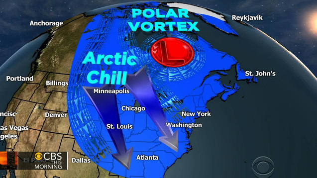

 Winter Storm Ion Bringing More Snow
  Life Threatening Cold


