Monday 31 March 2014

California Drought to end by an El Nino? Just may happen. Read the story.

California Drought to end by an El Nino? 
Just may happen. Read the story.

There are indications that an El Niño is on the way for the middle and latter parts of 2014. 
The phenomenon may impact the weather in portions of the United States, starting this summer. 
Fluctuations in the sea surface temperature over the tropical Pacific Ocean have been observed and recorded for approximately the past 60 years. 
These fluctuations are known as the El Niño Southern Oscillation or ENSO. 
When the waters are cooler than average for a several-month period, the event is called La Niña. 
Opposingly, when the waters are warmer than average over several months, the event is called El Niño.


There are indications that an El Niño is on the way for the middle and latter parts of 2014. 
The phenomenon may impact the weather in portions of the United States, starting this summer. 
Fluctuations in the sea surface temperature over the tropical Pacific Ocean have been observed and recorded for approximately the past 60 years. 
These fluctuations are known as the El Niño Southern Oscillation or ENSO. 
When the waters are cooler than average for a several-month period, the event is called La Niña. 
Opposingly, when the waters are warmer than average over several months, the event is called 
El Niño.

While El Niño will not have an impact on this spring and summer's severe weather, it may come on early enough and strong enough to have impact on the upcoming hurricane season in the Atlantic and Eastern Pacific.
Disruptive winds, known as wind shear, often develop off the Atlantic coast of the United States and sweep over a large part of the basin during El Niño. 
El Niño is generally not a major player in determining the number and strength of storms that originate over the Gulf of Mexico and much of the Caribbean. 
While the number of storms tends to be lower in the Atlantic during an El Niño, it is not uncommon for the Eastern Pacific to have a very active hurricane season. 
An El Niño may also enhance the summer monsoon over the Four Corners region of the Southwest as tropical moisture funnels in from the Eastern Pacific. 
Whether monsoon moisture is enhanced over drought-stricken California is less certain at this time.

However, there is some hope for rain later in the year that could impact the California drought, which has been weighing heavily on ranchers. 
The greatest effects on the weather pattern in the Lower 48 states, including California, occur during the cold season.

As far as impact on next winter, it is too early in the game to make a call one way or another, but some El Niño patterns in the past [1997-98] have produced significant storms in California. 

El Niño winters are noted for wet and stormy conditions in the South and less-frequent, less-severe cold episodes in the Northern states.

The pattern has been known to bring outbreaks of severe weather in the South during the winter. 
There is a tendency toward dry conditions in the Northwest and North Central states during an El Niño winter.


Sunday 30 March 2014

Quick Update: Thunderstorms Possible This Afternoon

Quick Update: Thunderstorms Possible This Afternoon

MARCH 30, 2014

It’s been one heck of a week thunderstorm wise, and even today (Sunday), we may not be out of the woods completely.


Cold air aloft combined with mostly sunny conditions across the region will promote moderate to very steep low-level lapse rates, with mid-level lapse rates in the 7 – 7.5c range, which is moderately steep. A bit of lower-level moisture combined with the decent lapse rates will also support surface-based CAPE values to climb into the 100 – 300 j/kg range, locally a bit higher, from around Sacramento north. Shear today isn’t too strong, however winds do veer decently with height, and terrain-enhanced winds in the lower levels may be sufficient for some robust updrafts today, even with limited general upper support.

Mesoscale analysis most-unstable CAPE (fill) and visible satellite in the background, from 10:30am.

Convection allowing high resolution models including the 4km NAM, NSSL WRF, and HRRR indicate showers and possible thunderstorms developing along the west side of the Sacramento valley this afternoon, moving east to northeast through the early evening. HRRR indicates slight potential for some rotating thunderstorms given terrain enhanced shear in the central and northern Sacramento valley.


Modest instability and shear could be sufficient enough to support thunderstorms capable of hail and gusty winds, however if the HRRR is near-correct, cannot rule out a rotating storm or two in the Sacramento valley this afternoon/early evening, generally north of Sacramento with the hotspot highlighted by the HRRR being between Yuba City and Redding.

15z HRRR’s forecast radar reflectivity for around 5pm.

Things decay after around 7 – 8pm ahead of our next, stronger system. I’ll have an update out this evening regarding this system, I just didn’t want to let today’s threat go unposted.

Friday 28 March 2014

Wet System Late Friday/Saturday, Thunderstorms Again Possible

Wet System Late Friday/Saturday, Thunderstorms Again Possible

MARCH 27, 2014

What a week it’s been! Two days of supercells in Glenn and Butte counties, with Wednesday having supercells from the northern San Joaquin valley to Glenn/Butte counties. With all the action we've seen, we still aren't done just yet.

For more information on the Glenn & Butte county tornadic supercell, check out this here review I posted: Glenn County Tornadic Supercell Review

Yet another large upper low and associated surface low will push eastward and become quasi-stationary off the Pacific Northwest coast Friday. It has already tapped into a subtropical moisture plume from the Hawaiian Islands, and though not a significant moisture tap, it includes precipitable water values in the 1 – 1.2″ range being transported into OR/CA via a combination of the main Pacific jet and a subtropical jet. This strong/dynamic jet streak energy, moisture, and cold air aloft associated with the upper low will dig the trough further south and enhance a vorticity max off the California coast.


As the vort max pushes toward the California coast Friday night into Saturday, a cold front will slide through bringing a band of moderate to locally heavy rain given the above mentioned moisture and jet dynamics in addition to strong lift. The frontal precipitation band should arrive along the north coast by Friday morning, into the coastal mountains, northern mountains, and northern valley by mid to late-afternoon, and begin filling into the central valley by early to mid-evening. Front slows as it slides further south, and finally reaches the I-80 corridor by the early morning hours of Saturday. The band may stall out from around SFO up the I-80/Highway-50 corridor through at least the late morning hours Saturday, possibly into the afternoon. It should finally arrive in the San Joaquin valley by mid-morning.

Convection could once again be something to keep a close eye on with this system. Given a more noticeable system closer to our coast (in this case the vort max), and a deeper trough, colder air aloft with punch further south compared to storms earlier in the week. -25c 500mb temperatures arrive overhead by the afternoon and evening, which will promote some steepening lapse rates along a leading plume of the cooling upper-level air. Given a 100 – 130kt jet carving through California Saturday, speed shear will be strong, but directional shear is a bit more iffy. The GFS indicates great low-level southeasterly winds and decent southwest to WSW winds at 500mb, while the NAM indicates westerly surface winds and westerly 500mb winds from Yuba City to Stockton… with somewhat in the way of better veering north to Redding. Overall, for now, I’d expect great speed shear and at least modest directional shear.

300mb winds and 500mb heights plotted through the 0z 12km NAM, valid for around 2pm Saturday.

Clearing is again iffy with this setup. If the front exists by early to mid-afternoon in at least half of the Sacramento valley and allows for some partly cloudy skies to develop and boost surface temperatures into the upper 50s to low 60s, buoyancy and CAPE would be sufficient for thunderstorm development again. The NAM indicates MLCAPEs in the 100 – 400 j/kg range Saturday afternoon in the northern San Joaquin valley north to around Chico, and that’s without widespread clearing. If clearing were to occur, CAPE/LIs would be higher than that, and (low-level) lapse rates would also skyrocket.

Forecast mixed-layer CAPE via the 0z 12km NAM, valid for 2pm Saturday.

There is certainly potential for strong thunderstorms Saturday if clearing occurs, but confidence in rotating storms in my opinion needs another day to elapse for models to get a better handle on timing of all the elements.

Aside from convection, snow levels initially with the front Friday night should start out around 6000 – 6500ft, but drop off to around 5000ft later Saturday.

Precipitation totals will range from 1/2 – 1″ of rain in the valley in general, but along the east side of the valley upwards of 1.5″ is possible given decent upsloping/orographics in the sierra banking up against the foothills into the east side. Higher up, the foothills should see anywhere from .75 – 1.5″ in the south, to 1 – 3″ in the central and northern foothills. The western slope of the sierra is expected to pick up 2.5 – 4″ of liquid, locally a bit more in orographically favored areas. .5 – 1.5″ along the coast, with perhaps locally up to or near 2″, and lastly, 1 – 3″ in the coastal and northern mountains. These liquid QPFs would translate to 1 – 2ft of snow above 6000 – 6500ft late Friday – early Sunday.

Forecast QPF via the 0z GFS. 0z NAM/4km NAM came in dryer, thus for now I’ll disregard it’s QPF.

Sunday for the most part should be generally drier, however leftover cold air aloft could support some scattered convection, but nothing widespread/significant is expected.

A larger and stronger low drops out of the Gulf of Alaska over the weekend and winds up off either the Pacific Northwest or OR/CA coast by Monday, and brings another round of rain, snow, and potentially another thunderstorm threat. This system could dump precipitation amounts similar to the Friday/Saturday system, except it’d be a bit cooler, with lower snow levels and more snowfall in the mountains. More information on this over the weekend.

Forecast 500mb relative vorticity and heights valid Monday afternoon, via the 0z GFS.

I’ll have a update out Friday night regarding Saturday’s system, mainly the convective threat, and an update Saturday night for the Monday/Tuesday system, and probably again Sunday night to get a closer look at the possible convective threat Monday. It’s certainly been a busy week, perhaps some early and belated birthday presents given mine is Friday? Probably not, but nonetheless very enjoyable! Stay tuned!


Through the morning Wednesday, an upper level impulse traveling along a rather strong jet impacted northern California, bringing a round of showers to northern California. This upper level system was associated with a upper low off the Pacific Northwest coast, which was in the perfect position in to support decent vertical motion across northern California, along with the associated 100 – 120kt upper level jet.

Visible satellite imagery + radar mosaic from around 1:10, indicating some breaks between developing cumulus in the western central valley.

By early afternoon, a showers subsided in the northern and central Sacramento valley, which promoted partly cloudy skies and allowed surface temperatures to warm into the upper 50s to locally low 60s. At 500mb, temperatures were around -25c in association with the upper low to the north, which combined with ambient surface hearing promoted mid-level lapse rates around 7 and low-level lapse rates in the 8 – 9c range. In addition (and somewhat more importantly), decent moisture in the low/mid-levels combined with good cooling with height allowed for SBCAPE values to rise into the 200 – 500 j/kg range from Sacramento to around Red Bluff, which is sufficient for thunderstorm development in combination with the decent upper-level support and moisture.

Given the proximity to the upper low off the PNW coast and the decent jet blasting overhead, the positioning of the low made for fantastic directional shear Wednesday. Surface winds were out of the south to southeast in the valley Wednesday, and from around 4000 – 5000ft up, they were out of the west-south-west to west, and moderate to strong in speed above 5000 – 10000ft. Surface winds themselves in the central valley Wednesday were breezy from Sacramento to Red Bluff, with gusts in the 20 – 25mph range. The great directional and low-level shear made for noticable clockwise curving hodographs, also supporting the fact that the directional shear again was fantastic.

Take a look at this vertical wind profile from KDAX, the US National Weather Service Sacramento California’s radar site near Davis. The latest profile is on the far right, with the lowest wind barbs being at/near the surface and the highest barb available at/near 18,000ft, in this case. Notice the surface wind barb is out of the southeast, while winds above around 3,000 – 4,000ft and up are from the southwest to west-southwest. These veering winds with height are fantastic for rotating thunderstorms, but we need to get some sunshine in the valley for instability to be sufficient enough to support strong enough thunderstorms to make use of this excellent directional shear.

A forecast hodograph for the central Sacramento valley for Wednesday afternoon.

With these ingredients in place, the probability of strong to tornadic thunderstorms was moderate to high if the sun were to break through – and it did.

By noon to 2pm, the partly cloudy skies in the central valley had lasted long enough and promoted strong enough buoyancy to aid in the development of a thunderstorm in central Glenn county by 2 – 2:30pm.


More than a hour later, the storm finally began to move, which was around 3:30 – 4pm. Once eastward progression began, the storm began rotating more noticeably, and produced it’s first viewed funnel cloud around 4:40pm.


First funnel we and other spotters and chasers spotted around 4:40.

Around 5:30, the supercell finally crossed I-5, and produced at least two more funnels, and possibly one weak touch down. We noticed quite a bit of dust being kicked up in a field in front of us north of SR-162 between Williams and Glenn.


Just a few minutes later, a full condensation funnel made it to the ground west of I-5, and touched off and on for 1500ft according to the NWS in Sacramento’s survey, and was also rated a EF1 given several dozen almond trees were uprooted, along with some damage to outbuildings.


In addition to this and a bunch of other photos, here’s a video we captured of the development of the tornado, and towards the end it either weakens and fades or becomes invisible due to rain wrapping around the mesocyclone. Link to the video via YouTube is below.


During this time, the supercell on radar looked amazing, with a clear hook, BWER, and some rather strong surface inflow.

In this four-panel view, you can see your standard base reflectivity up in the top left, storm-relative velocity in the top right, correlation coefficient in the bottom left, and differential reflectivity in the bottom right. In the bottom left (CC), there is a one pixel that lasted a couple frames of some low values, which which contained within the hook and associated meso, and could have been a small amount of tornaod debris being pulled up high enough to be detected by the radar.

Shortly after this frame, the tornado dissipated, though the storm continued to rotate into western Butte county.

Around the same time, a smaller supercell spawned several funnel clouds and one tornado in Roseville as that supercell tracked from eastern Sacramento county east into Placer county.

This event goes to show, that tornado events do happen in California, and perhaps most commonly in the Sacramento/San Joaquin valleys. The frequency seems to be one to three times per winter/spring, depending on the year.

Sunday 23 March 2014

Unsettled Week Ahead

Unsettled Week Ahead, Convective Events Possible

MARCH 23, 2014

Have you enjoyed the last couple weeks of dry, warm, spring-ish weather? Well, you've got Monday left before things change for the better for us active weather lovers (at least for a couple days).


Monday, a deep low in the Gulf of Alaska begins extend southeast, with a secondary low within the larger-scale upper level low rotating off the Pacific Northwest coast by Tuesday. This low will send a cold front through northern California Tuesday, bringing the first precipitation in more than 2 weeks. This front will have a narrow moisture plume, thus making for a narrow precipitation band. 700mb vertical velocities are modeled to be moderate to strong (30 – 40 ub/s), with precipitable water values of .9 – 1″, which isn't very significant, but combined with decent lift should make for a burst of light to moderate rainfall over a duration of a couple hours.

18z NAM’s forecast 500mb winds and MSLP, valid Tuesday afternoon.

Currently, the NAM/GFS/ECMWF indicate the timing of frontal passage in the early to mid-morning along the coast, late morning in the northern/central Sacramento valley, and early afternoon for the southern Sacramento valley. If this timing is correct, the post-frontal cold pool may slide over the central/northern Sacramento valley in-time to allow for some convective activity, if clearing were to occur behind the front. If the front were to slip through a few hours faster, stronger diurnal heating beneath a -20c 500mb cold pool would lead to steeper lapse rates and better convective potential. Instability lingers into the overnight Tuesday, thus continuing a chance of convection through the overnight.

Overnight Tuesday into Wednesday, the low off the Pacific Northwest coast rotates a stronger shortwave around the low into northern California by the early to mid-morning hours. This secondary shortwave will not have a great moisture source to work with, limiting precipitable water values to .5 – .7″, however, this shortwave trough takes on more of a negative-tilt as a strong mid/upper level jet streak (100 – 120kts at 300mb, and 80 – 90kts at 500mb) rotates around the base of the trough. These dynamic forces will greatly make up for the lack of moisture, in addition to much colder air aloft and increasing instability.

18z NAM’s forecast 500mb winds and MSLP, valid Wednesday afternoon. Note the band of strong jet stream level winds along the west side of the trough, blasting southward digging the trough deeper into California.

This second shortwave will swing through bringing a widespread increase showers through the morning and afternoon Wednesday as lift and forcing increases. -25 to -28c 500mb temps aloft Wednesday will make for even steeper lapse rates compared to those seen Tuesday, and while surface temperatures may be limited to the 50s due to significant cloud cover and shower coverage, cold air aloft combined with decent low-level moisture should be enough to promote between 100 – 300 j/kg surface-based CAPE values from the coast to the valley. If any pockets of clearing were to present themselves during the day Tuesday to locally boost buoyancy enough to get some deep convection going. Shear during the day Wednesday will be quite decent given the tilt of the trough and the position of the jet streak, supportive of some weak rotation with stronger storms. However, given a some uncertainty as to the coverage of cloud cover and precipitation Wednesday, thunderstorm potential is tough to tell at the moment.

Forecast 0 – 3km storm relative helicity, as well as 10-meter and 500mb wind arrows. Note that the (near) surface winds are out of the south, while the mid/upper level winds are jetting from the west, indicative of great directional shear.

Apart from thunderstorms/convection, between Tuesday and Wednesday the lower elevations of northern California could pick up anywhere from a quarter to half an inch of rain, locally up to three quarters of an inch depending on convective coverage Wednesday. Snow levels Tuesday are expected to be around 4500 – 5000ft in the sierra, perhaps dropping off a bit more Wednesday as the secondary shortwave comes through, possibly to 4000ft. 1 – 3″ of liquid precipitation in the foothills up into the highest peaks would translate to 10 – 16″ of snow above around 5000ft, locally up to 2ft.

18z NAM’s forecast snowfall through late Wednesday. 12km tiles may be masking higher totals, though.

Wind wise, given a ~990mb low off the Pacific Northwest coast, breezy winds are possibly Tuesday as a band of 30 – 40kt 850mb winds slides through with the cold front, and again Wednesday as the second, stronger shortwave rotates inland. Currently, these low-level winds would support some 20 – 30mph surface gusts in the valley and along the coast. Tuesday, in the mountains, a band of 50 – 70kt 700mb winds slides over the sierra/western Nevada, which combined with dynamics with the cold front could lead to 40 – 50mph gusts in favored terrain, locally higher as energy falls down the east slope of the sierra into western Nevada.

The trough exists Thursday, with warming into Saturday. Uncertainty exists beyond Saturday, as models have been trying to indicate another trough getting in here by Sunday or early next week, but consistency and agreement is very poor, so we’ll have to wait and see.

I’ll have another update on the for the Tuesday or Wednesday system depending how each one looks convective wise. If Tuesday looks to be convectively active, I’ll surely post something late Monday or before the afternoon Tuesday, and if Wednesday looks active as well, I’ll update Tuesday night or early Monday. Stay tuned, and enjoy the active weather while we’ve got it!


Cold End To March; Watching Midweek Storm In The Northeast

Cold End To March; Watching Midweek Storm In The Northeast

Weather Outlook
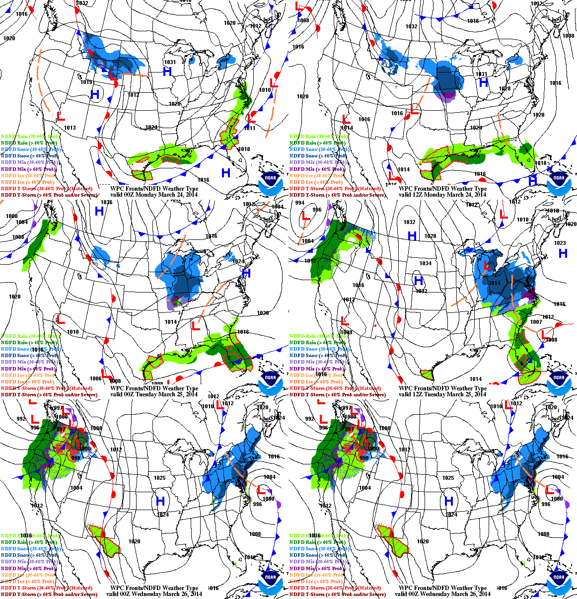
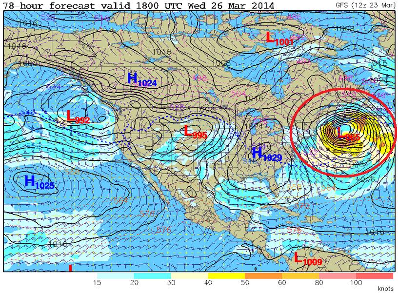
The clipper over the Midwest on Monday will actually play a role in the large storm system that looks to develop off the New England Coast by Tuesday.
Northeast Storm System
Weather models continue to indicate a very strong wave off the New England Coast by Tuesday/Wednesday. The wind field surrounding this storm looks to be quite impressive, which will likely impact the Northeast.
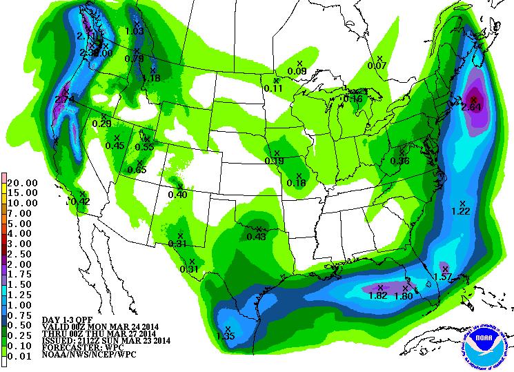
Precipitation Outlook
According to NOAA’s HPC 3 day precipitation outlook, the swath of precipitation that stretches along the Eastern Seaboard will be associated with the developing storm system. It appears that the heaviest precipitation has shifted just a little farther east. However, places right along the coast could see some heavier snow. Stay tuned for more!
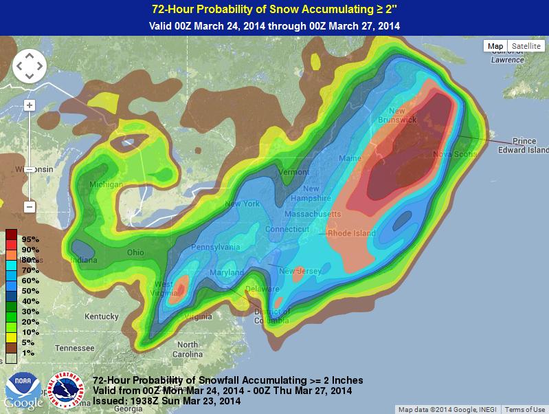
2″ Snow Probability
According to NOAA’s Weather Prediction Center, the probability of at least 2″ of snow through PM Wednesday is the highest right along the coast
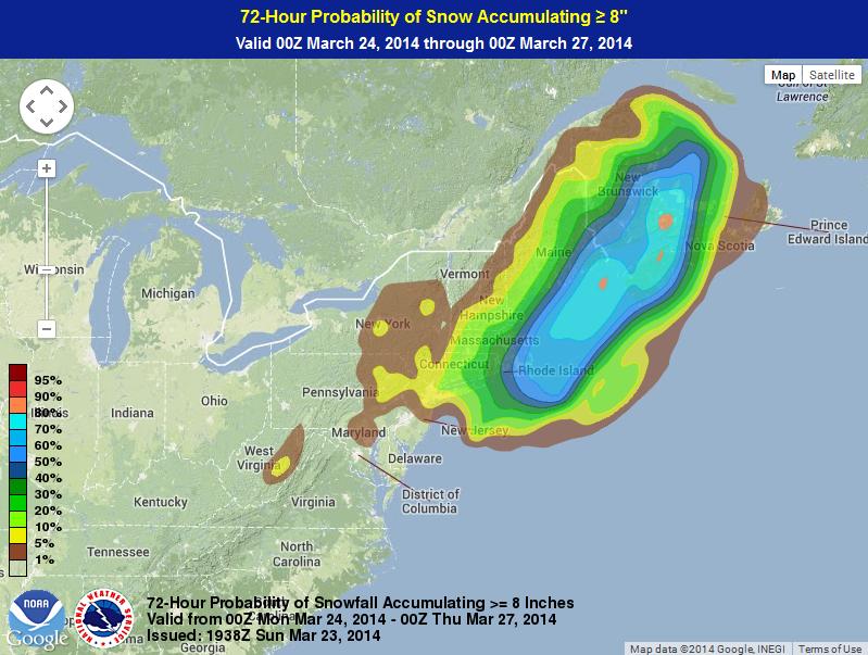
8″ Snow Probability
Here’s NOAA’s WPC probability of at least 8″ of snow or more through PM Wednesday is quite a bit less, but still shows the best potential right along the coast.
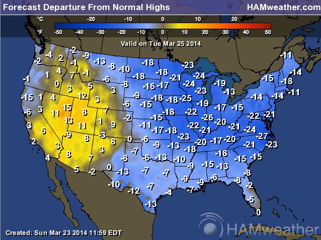
Continued Cold
Unfortunately, the much colder than average weather will continue across the eastern two-thirds of the country through much of the week. Here’s the temperature departure from normal outlook for Tuesday, which shows a significant amount of cold air (for this time of the year) east of the Rockies.
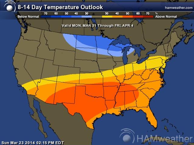
Extended Temperature Outlook
According to NOAA’s CPC, the 8 to 14 day temperature outlook suggests much warmer temperatures moving in across the southern half of the nation, while the Upper Mississippi Valley looks to stay a little cooler than average.
Sensing Lightning from the ISS
Here’s a cool story from NASA’s Earth Observatory, which talks about lightning being observed from space!
“Across the entire atmosphere of Earth, lightning flashes occur about 50 times per second. That’s 4.3 million times a day and 1.6 billion times a year. Using a new instrument on the International Space Station (ISS), scientists hope to capture and dissect at least a few of those flashes every day.
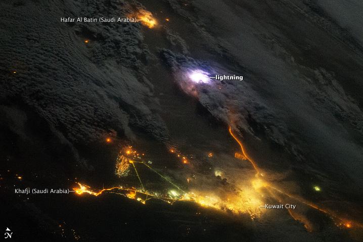
Installed on the ISS in August 2013, the Firestation instrument includes photometers to measure lightning flashes, radio antennas to measure the strength of the lightning, and a gamma-ray electron detector. The instrument was designed to observe about 50 lightning strokes per day and to look for brief bursts of gamma rays that are emitted by some of those strokes. Gamma radiation is usually associated with exploding stars or nuclear fusion, but scientists have found evidence that terrestrial gamma-ray flashes (TGFs) occur in the atmosphere as much as 500 times a day. They are interested in what processes trigger lightning within thunderstorms and what kinds of lightning produce gamma rays. TGFs may also be related to the atmospheric phenomena known as red sprites.

Sunday 16 March 2014

Threat of major earthquake

Posted on March 15, 2014

March 2014 – OREGON –
The Cascadia subduction zone is less known than the San Andreas fault, which scientists have long predicted will produce The Big One. But in recent years, scientists have come to believe that the Cascadia is far more dangerous than originally believed and have been giving the system more attention. The Cascadia begins at a geologically treacherous area where three tectonic plates are pushing against each other. The intersection has produced the two largest earthquakes in California in the last decade — Sunday’s 6.8 temblor off Eureka and a 7.2 quake off Crescent City in 2005. The area has produced six quakes of magnitude 7.0 or greater in the last 100 years, the California Geological Survey said. Officials in Northern California as well as Oregon and Washington are beginning to address the dangers. National Oceanic and Atmospheric Administration tsunami researchers are testing a new generation of tsunami detectors off the Oregon coast, which could provide earlier warnings about the incoming wave’s size. During the 2011 Japan tsunami, some of the first detailed alerts underestimated the size of the tsunami to be lower than the sea walls — and then communications were cut off. “So some people had a false sense of security,” said Vasily Titov, director of NOAA’s Center for Tsunami Research. “You want to have this information as accurate as possible.” Installing tsunami sensors on the deep ocean floor would provide better information on the tsunami’s size in as little as five minutes. It now takes about half an hour.
Titov said two underwater test sensors off the Oregon coast seemed to perform well in Sunday’s earthquake, though the quake did not produce a tsunami. In Grays Harbor County in Washington state, crews will begin building an elementary school gym this summer to double as a “vertical evacuation center” — built so that 1,000 people can flee to the roof during a tsunami, protected by a high wall. “We have no natural high ground,” said Ocosta School District Supt. Paula Akerlund. “So we have to evacuate vertically.” Washington state and federal officials have also been discussing building about 50 “tsunami safe havens,” such as artificial hills that could hold as many as 800 people. The 2011 Japan tsunami as well as other natural disasters like Hurricane Katrina have fueled efforts to better prepare for a major quake on the Cascadia fault. “Katrina was a worst case scenario for hurricanes in the gulf. And a Cascadia would be the worst case scenario for tsunamis on the West Coast,” said Paul Whitmore, director of the National Tsunami Warning Center in Alaska. For years, scientists believed the largest earthquake the area could produce was magnitude 7.5. But scientists now say the Cascadia was the site of a magnitude 9 earthquake more than 300 years ago. Ripping over a fault that stretches in the Pacific Ocean from the coast of Vancouver Island to Cape Mendocino, the quake on the evening of Jan. 26, 1700, was so powerful, entire sections of the Pacific coastline dropped by as much as 5 feet, allowing the ocean to rush in and leave behind dead trees by the shore. –LA Times

Share this:

Saturday 8 March 2014

Last Storm for a While Sunday into Monday

Last Storm for a While Sunday into Monday

 MARCH 8, 2014

It’s been a rather active last few weeks compared to the pattern we’ve seen over the last several months to a year! While we’re still in a major drought, the recent storms have helped out slightly to moderately locally, and we’ve got one last storm to go before we dry out for what looks to be at least one to two weeks.

This next storm will have another atmospheric river associated with it, including a long fetch of precipitable water values of 1 – 1.3″ extending into the east-central Pacific, northwest of Hawaii. A large upper low in the Gulf of Alaska is what’s driving this plume southward, ahead of a cold front. The system will loose a considerable amount of dynamic force as it gets south of the north coast, however a modest upper-level jet and decent lift, which in addition to a southwest flow in the mid-levels, will promote decent orographic lift in the northern sierra. In the valley, it appears rain-shadowing may limit precipitation quite a bit in the western central valley, but along the eastern side of the valley lift/banking against the foothills and western slope will support better precipitation potential.
700mb vertical velocity plotted through the 4km NAM, valid for 5am Monday. Areas of warm color indicate upward lift, with purples associated with the strongest lift and precipitation.

Timing is a little tough with this system, as pre-frontal showers are possible by mid to late-afternoon, with precipitation forming in the northern sierra and foothills of Butte county by early afternoon. The rest of the region should receive precipitation from the front by mid to late-evening, lingering into the early morning hours, clearing out by mid to late-morning. A bit instability may lead to a few showers through the day Monday, but nothing widespread or strong convection appears likely at the moment.

Snow levels will start out quite high, AOA 8000 – 9000ft, but may lower off a bit early Monday, perhaps down to 6000ft.

Rainfall amounts will range from a few hundredths to a quarter inch in the valley, to a quarter to half an inch in the foothills, half an inch to an inch in the higher elevations of the western slope, and 1 – 2.5″ in orographically favored south/southwest slopes from Placer to Shasta counties.
4km NAM’s forecast QPF through Tuesday. It ain’t much for the valley, but more notable in the higher elevations.

Stronger ridging slides overhead through Tuesday and is currently expected to remain overhead through at least the end of next week, at least according to current models. Highs by the end of next week could enter the mid to upper-70s to low 80s by weekend in the valley, with 40s to 50s in the highest elevations and 60s and 70s in the foothills.
Forecast highs next Saturday (March 15th).
And that’s about it! I wish there was more to write about, but really this coming storm isn’t too significant, the convective potential seems to be lacking, and the ridging behind it doesn’t need much explaining as to what it’ll bring besides increasingly warm temperatures.

If/whenever a storm presents itself, expect an update!


Wednesday 5 March 2014

Several inches of snow is expected in the Sierra.

North Bay Mountains 

I hope you have your umbrella with you. You'll need it between tonight - early tomorrow afternoon. Light rain is falling in the north bay. A cold front will move in late tonight & the rain will spread south & east. Rainfall is not looking great but it's better than nothing! The lower elevations will receive between a trace to .30" & the north bay mountains are expecting anywhere from a .50" to 1.5". The morning commute will include some damp spots as a few showers linger. Morning temperatures tomorrow will run mild, in the low to mid 50s and highs will make it to the 60s. Several inches of snow is expected in the Sierra.
Live Doppler7 HD has been picking up lightning strikes north of Clearlake this afternoon. There may be enough instability to trigger a thunderstorm or two so we'll keep in a slight chance for the north bay this evening.
We're getting lighting strikes near Chico. Small hail, heavy rain & gusty winds can be expected.

Heavy rain in Chico with the potential for small hail, gusty winds and lightning. Moving to the NE.

Band of showers and thunderstorms sweeping through the Chico/Paradise/Magalia area currently with potential small hail, gusty winds, and very heavy rainfall. This line will continue to drop south through the east side of the Sacramento valley into the adjacent foothills and mountains through the afternoon, but it's uncertain if it will produce more thunderstorms.

Another band or two will swing through this evening with more showers and thunderstorms.
Some scattered light showers right now around the Bay Area. More organized #rain later this evening

A cold front is moving into the N bay now. Moderate rain is showing up on Live Doppler7 HD at Bodega Bay & Healdsburg. That narrow band of rain will shift south & east overnight across the rest of the Bay Area while you're sleeping. An isolated shower may linger into the start of the rush hour tomorrow morning but that's about it. Give yourself a little more time to get the kids off to school or yourself to work since there will be some slick roads.

Another band of thunderstorms pushing into the Chico area currently. This band may contain some hail up to .5" in diameter, along with gusty winds and very heavy rain. The foothills to the east of Chico will also get in on this action over the next 30 - 45 minutes.

Looks like a good light show in Butte County.

.@LiveDoppler7HD tracking moderate ‪#‎Bayarearain‬ from Marin Co. to SF to Richmond now.. front is shifting south.

Storm cell rolls into Sydney


Portland Radar. NEXRAD Radar.

Weather On The One, Current National Temperatures

Weather.com Radar

Northern Weather