Weekend Weather Outlook
UPDATED 12:15 AM EDT, May 10, 2014
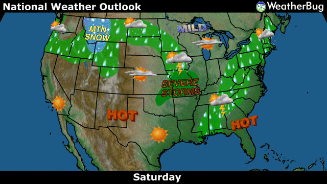
A wide range of springtime weather will run rampant across the U.S. this weekend, including everything from blistering heat not easing in the Southwest and southern Plains to fresh thunderstorms bubbling in the Mid-Mississippi Valley and even a bit of elevation snow across the northern Rockies.
Today: > Saturday ........
A weak cold front easing across the Eastern U.S. will squeeze out patches of heavy downpours and even a few thunderstorms from southern New England into the Mid-South. The shower and thunderstorm activity, although not severe, will likely force more than a few outdoor plans indoors this afternoon and evening. Temperatures in New England and the Mid-Atlantic will be in the 70s, while highs heat up into the 80s in the Mid-South and Southeast.
Rain and even a few mountain snow showers will keep the remainder of the Northern Tier occupied for the start of the weekend. A disturbance swirling across the northern Rockies will deposit a chilly rain for the valleys from the Northwest into the central Rockies, while a few snowflakes will greet residents in the higher elevations of these same locations today. Further east in the Mid-Mississippi Valley, a warm front attached to the same system will unleash a barrage of powerful late-day thunderstorms in places such as Kansas City and St. Louis, Mo.; large hail and gusty winds will be the main hazards.
The mercury will range from the upper 30s to lower 40s in the higher peaks of the Rockies, with 40s and 50s blanketing the Pacific Northwest and lower valley locations along the Rockies today. Highs will climb into the 70s and 80s in the Mississippi Valley.
Abundant sunshine and torrid heat will plague the southern Plains and Desert Southwest with highs in the 90s. The central Plains and West Coast will see temperatures in the 70s and 80s while the Upper Midwest stays comfortable in the 60s.
Sunday: > Mothers Day...........
The Central U.S. will be the main target for wild weather on Sunday. Rain will stretch from the Upper Midwest and Great Lakes to the central Plains while thunderstorms, even a few quite powerful, brew from the western Great Lakes all of the way to Texas' Big Bend area. Gusty winds on top of the rain will ruin outdoor plans from Colorado and Utah to the Dakotas, while thunderstorms in the Central U.S. carry all severe weather threats. Temperatures will vary from the 50s and 60s in the Upper Midwest to the 70s in the Mid-Mississippi Valley and central Plains. Highs in the 80s will spread from the Ohio Valley to the southern Mid-Mississippi Valley and southern Plains.
Further west, the Intermountain West will be the only other competitor for wet weather. A pocket of mountain snow will add a fresh layer to the central Rockies snowpack as well while lower elevations see a rejuvenated soaking. Temperatures in the central Rockies will be in the 40s while the Intermountain West rises into the 50s and 60s.
Scorching heat will keep the Southern Tier and Eastern U.S. quite toasty as the weekend comes to a close. Temperatures in the 80s and 90s will stretch from the Mid-Atlantic and Southeast, through the Lower Mississippi Valley and southern Plains and into the Southwest.
Warm but comfortable temperatures in the 60s and 70s will be accompanied by sunshine in the Northeast, West Coast and Pacific Northwest. The northern Plains and northern Rockies will keep cooled off in the 50s.

No comments:
Post a Comment